Airspace & Waypoints
Airspace
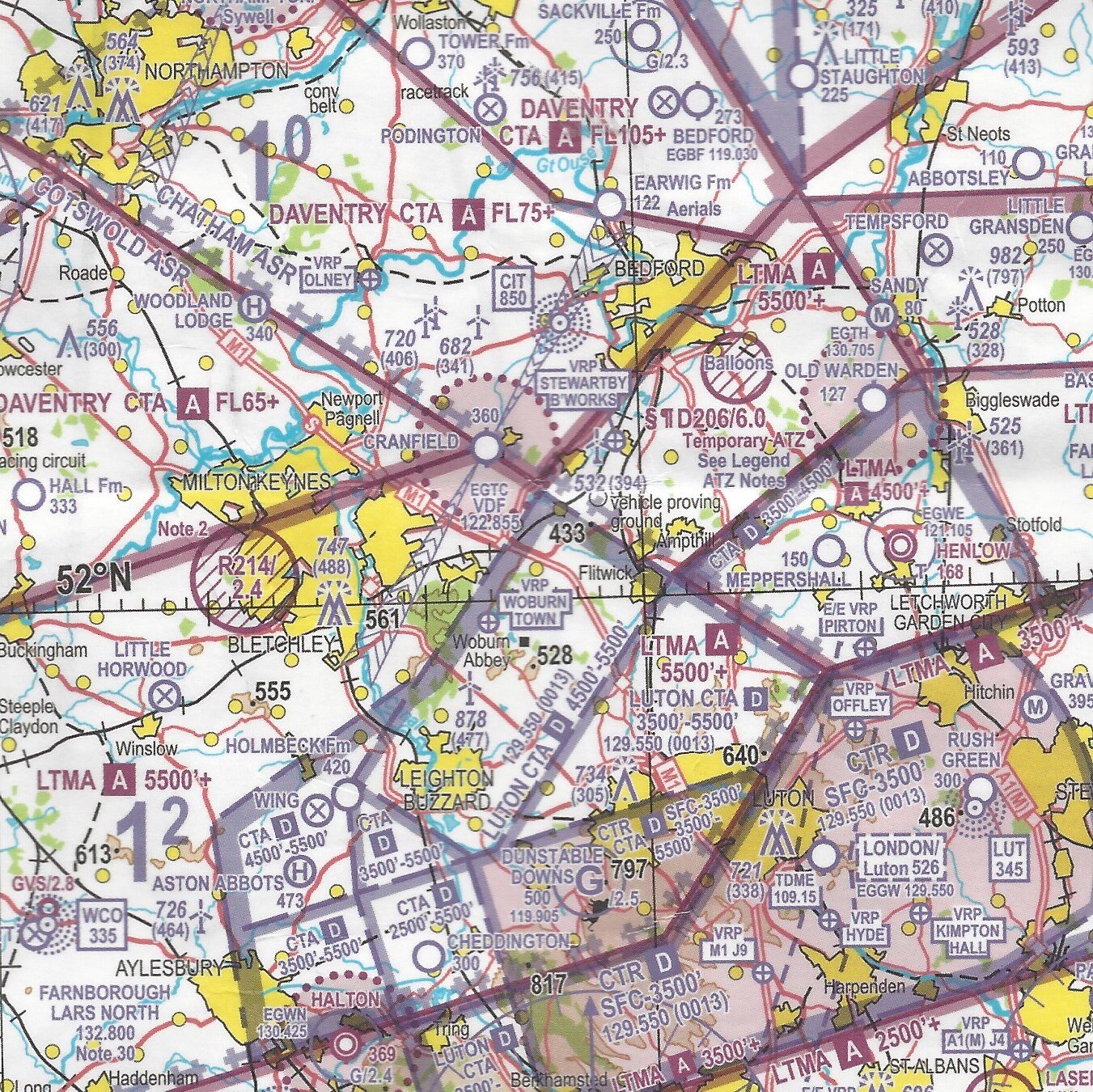
Dunstable Airfield is located within Luton Airport’s CTR, which is Class D airspace.
We are only able to fly from Dunstable Airfield thanks to the negotiation of a Letter of Agreement with NATS.
All pilots operating an aircraft to or from Dunstable Airfield must comply with the negotiated terms of the Letter of Agreement. As part of this, and to ensure the safety of all persons and for the continued existence of the London Gliding Club, it is vital that:
All pilots know and abide by the local operational procedures and the local airspace boundaries;
All pilots have an LGC Airspace Rating before using the airspace concessions granted under the Letter of Agreement; and
Any visiting pilots obtain approval and a full briefing from the CFI or a nominated deputy before flying to or from Dunstable Airfield
For the avoidance of doubt, the obligation to know and abide by the negotiated terms of the Letter of Agreement is a personal obligation of any pilot operating an aircraft into or out of Dunstable Airfield.
The Letter of Agreement allows LGC pilots to operate within certain parts of controlled airspace at times when they are not being used by commercial air traffic.
If, without the appropriate authority, you enter the parts of the Luton CTR and CTAs that are only available to LGC pilots per the Letter of Agreement, you will be committing an offence under the ANO and be liable to prosecution. You also risk entering airspace that could be in use by Commercial Air Traffic, with the potential to endanger lives.
To assist in understanding and navigation, various files are made available for download.
All the files shared here have been prepared in good faith, but to the extent that they are made available by the club and/or its members that it is done, and any subsequent use is, without assumption of responsibility so far as permitted by law. There are inherent risks that such files contain errors of any sort and it is understood and agreed by any person using such files, that they do so entirely at their own risk.
Briefing materials
At LGC we operate a safety culture in which all pilots seek to improve and maintain the safety of all operations at LGC.
As part of this club members use formal and informal processes to assist new and existing members teach themselves:
(i) the local operational procedures
(ii) the local airspace boundaries
(iii) verify annually that these procedures and boundaries are known by existing and new club pilots.
The airspace briefing is available at the bottom of the page.
It contains briefing materials which supplement the annual mandatory airspace briefing which all flying members of LGC must attend.
Files contained in airspacebriefing.zip include:
A pdf file containing a subset of the slides from the PowerPoint presentation used in the LGC Airspace Briefing plus aerial photos showing some of the ground features used to identify boundaries.
High- and low-resolution images of the airspace boundaries chart.
Local airspace charts for printing and carrying in cockpit.
kmz and gpx files for viewing the boundaries of Basic and 25-Alpha in Google Earth or OS Maps.
A readme.txt file containing further details about the above.
Airspace Files for Moving Map Devices

Updates to the UK Aeronautical Information Publication (AIP) are published on a 28 day cycle, which is determined by the AIRAC schedule. It is important that you keep up to date throughout year to make sure any changes to UK airspace are reflected in the files that you use for navigation. If you do not use a moving map but rely on a half-mil or quarter-mil chart, you must still ensure you are aware of any airspace changes that have been implemented since the chart was published.
You can generate your own airspace files for moving map devices using ASSelect
As above, please remember that it is YOUR responsibility to ensure that you are using the most up to date airspace information when planning your flight, including checking NOTAMs.
Note the following comment from Alan Sparrow, who maintains ASSelect and its website: “I try to make this data accurate, but there will still be some errors. Please don’t blame me if you go somewhere you shouldn’t have gone while using this data!”
The files generated by ASSelect include the Luton CTR and CTAs as shown on standard half-mil and quarter-mil charts. To include the LGC airspace in these files, the output from ASSelect needs to be amended manually. Informally such airspace files are shared by club members periodically, always on the clear understanding that any use of the same is at the pilot’s own discretion and risk, and without assumption of any liability so far as permitted by law. Such files, by their nature, are prone to error and may prove to be inaccurate.
The airspace files are available at the bottom of the page.
No matter how accurate the data is, it is useless if not properly used. The pilot is also responsible for understanding how to correctly load and select the files on their moving map devices and setting appropriate alerts, in order to be given timely warning of proximity to various classes of prohibited airspace.
Files contained in airspace-files.zip include:
UK Airspace files in cub (SeeYou) and OpenAir format, generated using ASSelect and edited to include LGC local airspace.
A text file summarizing changes made in ASselect to airspace during the previous twelve months.
Even if you do not use a moving map, this file will be useful to show what has changed since your half mil chart was published!Local airspace files in OpenAir and TNP format, containing just the Luton CTR and CTAs, edited to include LGC local airspace.
A guide to using ASselect to create your own airspace files
A readme.txt file containing further details about the above.
Important: You must not use the LGC airspace files without a full understanding of the local procedures that make certain parts of Class D airspace available to LGC pilots at certain times, depending on the runway in use at Luton Airport.
Between March and October, the zip file will be replaced, approximately every four weeks, with a new file containing updated UK airspace files. The updates will normally occur about two weeks before the next AIRAC effective date (which will be listed in the readme.txt file). Files that are no longer current will be removed.
When possible, RA(T)s and other temporary restrictions that are likely to affect flights from Dunstable will also be included in the UK airspace files, or as separate files in both OpenAir and .cub format.
During the winter months updates may only be made if changes are implemented that are likely to affect local flying from Dunstable. Pilots who intend to fly in other parts of the UK over the winter should ensure that they use appropriate files for the area they intend to fly in.
Waypoints
Details of the BGA Waypoint List can be found at the bottom of the page.
You can use TPSelect to generate your own Waypoint files based on the BGA Waypoint list, which is normally updated every February/March, but sometimes additional modifications are made later in the year.
You should always use an up to date Waypoint file, as points are often revised/added/removed from the list for a variety of reasons. TPSelect also allows you to select a subset of the current BGA list, if your device cannot cope with the nearly 1400 points that it contains, and it can output in a variety of different formats suitable for most popular moving map devices.
For LGC club members who just need a basic, up to date Waypoint file with no special requirements, three Waypoint files in SeeYou (.cup) format, are available. waypoints.zip contains the following files, it can be downloaded from the bottom of this page.
bga2024.cup full BGA 2024 Waypoint list as produced by TpSelect
lgc2024a.cup as above, but with some modifications and additions (see below)
lgc2024b.cup as lgc2024a, but with the name field modified to be preceded by the trigraph
The waypoint description fields in both ‘lgc’ files have also been modified to remove some unnecessary verbiage that they contain (e.g. ease of finding visually).
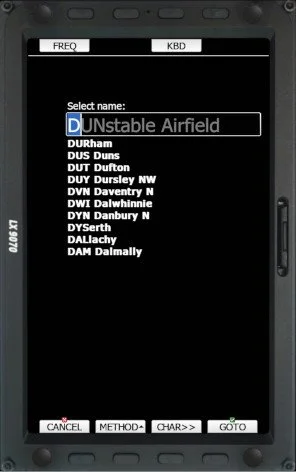
In lgc2024b.cup, the first three characters of the name field will be the same as the trigraph and in uppercase. e.g.
"Leighton Buzzard NE" becomes "LBZ Leighton Buzzard NE"
"Dunstable Airfield" becomes "DUNstable Airfield".
This makes waypoint selection easier on some moving map devices, and helps to distinguish between waypoints that have similar names.
The ‘lgc’ files also include these additional, non-BGA waypoints:
DU1 Dunstable Chalk Hill
(Marks the NE Corner of the Chiltern Ridge Soaring Area)
LLR Llanbedr Airfield
(Not on the BGA list, but is still used by LGC expeditions)
PNA Peniarth Airfield
TYB Talybont Airfield
(both are potential outlanding for Llanbedr expeditions)
Downloads
-

Airspace Briefing
-

Airspace Files
-

Waypoint Files